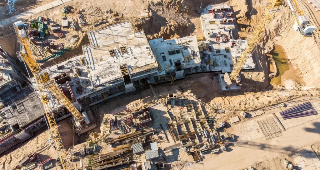
Applications of drones in construction and infrastructure sites have played an important role in acquiring high-quality data and allowing a safer ambiance for surveying construction projects. The quality of data acquired surpasses conventional photography techniques. Unmanned aerial vehicles excel at quickly gathering data from locations and points inaccessible to humans. When surveying difficult lands and difficult to reach areas, implementing drones make it no longer essential for personnel to access that location physically. It is also a cost-efficient method that can capture data in a shorter timeframe. A construction firm implementing an aerial photography solution can streamline project planning and future developments that help reduce project time. The firms can be companies managing sizeable construction projects that need monitoring and project management to optimize their operations. The intricacies and scale of larger projects come across many challenges that can be solved with the help of drones. The solutions offered by drone imagery can help with the early detection of issues that would decrease construction error and the need for reworking.
Streamline and execute projects with smart decisions
1
Enhanced Efficiency
Drones can help bridge the gap between running behind schedule and achieving deadlines on time. As they are one of the faster ways to collect data in a shorter time.
2
Safer Environment
The construction sites are prone to accidents and mishaps; drones can hover in the area that can be safe for a worker. They can help with accessing information about the site & conditions to be expected through aerial photos.
3
High Resolution Data
For retrieving topographic data, remotely piloted drones can hover closer to terrain surface and provide high-definition data that accurately represents the project that is being surveyed.
4
Monitor Progress
Using drones allows one to have real-time control over the progress of the project. Drones offer to keep track of developments visually that can always shape the next step and help make better decisions.
impact of drones in the construction industry
• Improved Site Monitoring: The construction of linear infrastructures such as roads and railways is a time-consuming endeavor. Drones help monitor the progress of construction in real-time. In the case of mining and valuable infrastructure site monitoring, drones eliminate any kind of uncertainty about the progress of the project.
• Stockpile Volume Calculation: Many construction sites and aggregate industries primarily use drones for stockpile inventory management. Calculating stockpile volumes helps track the site’s progress. With the help of aerial data and utilizing appropriate software tools, we can calculate stockpile volume and estimate the amount of material that needs to be added or removed.
• Estimating Dimension of Structures: Drones capture better topographic information as compared to other conventional methods. The aerial data provides more accurate measurements of width, height, and land area. By implementing automated GIS methods, we can understand the steepness of the ground and collect precise dimensions of any structure.
• Inspection for Maintenance: The high up infrastructures such as bridges and towers needs planned inspections methods for their maintenance. It is difficult to access such areas. Traditional methods prove to be cost-inefficient and riskier for site personnel. Drones impart unchallenging and simple solutions for carrying out such inspections.
Monitor your worksite with drones
Aerial data can be utilized throughout the project lifecycle, from pre-planning to delivery and maintenance. During the pre-planning phase, before the start of many construction projects, the land is surveyed to gain an insight into the environment of the site. While in the construction phase, the managers have to control and verify finished work. As one is quickly able to access and validate work, one can move to the next step of project development. Faster access to project monitoring can be achieved by drones, saving time throughout the process. The visual data from drone photography helps in real-time monitoring and controlling operations of construction sites.
Achieve your project targets on time, on budget
Achieve your project targets on time, on budget
By employing drones, a construction firm can create an overview of the site that would help one track progress and spot any mistakes and errors. Area of safety is most important for plant reliability and project operations; such a safer environment can be created by employing drones. The project monitoring helps in the early detection of issues can help decrease construction error, and re-work. Surveying drone solutions provide data with high degrees of accuracy. In a single flight, the aerial imagery offers immense information in a shorter time. A drone can survey larger areas within hours at a very lower cost. Drones are the best solutions for creating safer environments, progress monitoring, and at an efficient cost and time.